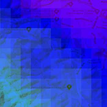
Wind Speed Maps
Work with your preferred spatial analysis platform to conduct in-depth analysis and create wind maps. Access comprehensive wind data provided in standard GIS-compatible formats.
What is included
Raster Data
- Format: GeoTIFF
- Resolution: 200m
- Annual Average Wind Speed at user-defined hub heights
- Digital Elevation Model (DEM)
- Roughness
Vector Data
- Format: Geopackage or ESRI Point Shapefiles
- Resolution: 2km
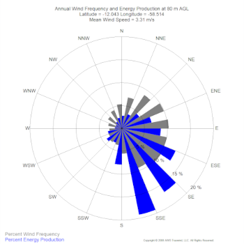
- Wind Distribution Data (wind speed, power, Weibull A and k, and frequency percentages in 1 m/s bins)
- Annual Average Wind Speed at four user-defined hub heights
- Wind Rose - frequency and speed in 16 direction sectors
- Roughness
- Monthly Data - average annual wind speeds by month
- Diurnal Data - average annual wind speeds by hour
- Air density, Power density & Weibull parameters new
KML Files
- Format: .KMZ
- Resolution: 200m
- View and modify map in Google Earth
- Annual Average Wind Speed at user-defined hub heights
Tip
Integrate this data with OpenWind to determine your offsets and developable areas for comprehensive wind farm planning. Learn more about OpenWind.
News & Highlights
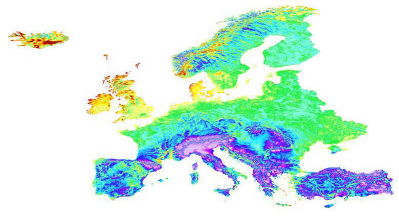
White Paper - Europe Wind Map - Methods and Validation
November 25, 2025
The 2025 Europe wind map released on UL Solutions’ ULTRUS™ Windnavigator Resource Data
and Maps software is a major upd...

White paper - Northern American Map
January 28, 2025
This report describes the methods and models behind the 2024 Northern American wind map, including comparisons showing t...
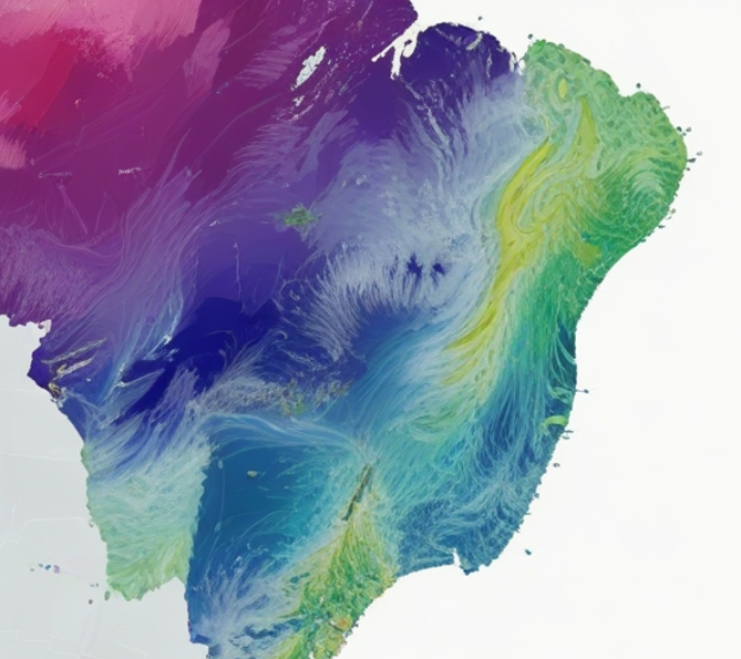
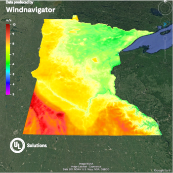
Brazil Wind Resource Map 2024
May 9, 2024
Updated and validated Brazil map. The adjustment with the new 216 towers has allowed us to reduce the bias to a residual...
Available Wind Speed Maps
Afghanistan
Alabama
Albania
Alberta
Algeria
Andhra Pradesh
Andorra
Angola
Anguilla
Anhui
Antigua and Barbuda
Argentina
Arizona
Arkansas
Armenia
Aruba
Arunachal Pradesh
Ashmore and Cartier Islands
Assam
Australia
Australian Capital Territory
Austria
Azerbaijan
Bahamas
Bahrain
Bangladesh
Barbados
Beijing
Belarus
Belgium
Belize
Benin
Bhutan
Bihar
Bolivia
Bonaire, Saint Eustatius and Saba
Bosnia and Herzegovina
Botswana
Brazil
British Columbia
British Virgin Islands
Brunei
Bulgaria
Burkina Faso
Burundi
California
Cambodia
Cameroon
Canada
Canary Islands
Cape Verde
Cayman Islands
Central African Republic
Chad
Chandigarh
Chhattisgarh
Chile
China
Chongqing
Christmas Island
Colombia
Colorado
Comoros
Connecticut
Coral Sea Islands
Costa Rica
Croatia
Cuba
Curaçao
Cyprus
Czech Republic
Dadra And Nagar Haveli
Daman & Diu
Delaware
Delhi
Democratic Republic of the Congo
Denmark
Djibouti
Dominica
Dominican Republic
East Timor
Ecuador
Egypt
El Salvador
Equatorial Guinea
Eritrea
Estonia
Ethiopia
Falkland Islands
Finland
Florida
France
French Guiana
Fujian
Gabon
Gambia
Gansu
Georgia
Germany
Ghana
Goa
Greece
Grenada
Guadeloupe
Guangdong
Guangxi
Guatemala
Guinea
Guinea-Bissau
Guizhou
Gujarat
gunia
Guyana
Hainan
Haiti
Haryana
Hawaii
Hebei
Heilongjiang
Henan
Himachal Pradesh
Honduras
Hong Kong
Hubei
Hunan
Hungary
Iceland
Idaho
Illinois
India
Indiana
Indonesia
Iowa
Iran
Iraq
Ireland
Israel
Italy
Ivory Coast
Jamaica
Jammu & Kashmir
Japan
Jharkhand
Jiangsu
Jiangxi
Jilin
Jordan
Kaliningrad
Kansas
Karnataka
Kazakhstan
Kentucky
Kenya
Kerala
Kuwait
Kyrgyzstan
Laos
Latvia
Lebanon
Lesotho
Liaoning
Liberia
Libya
Liechtenstein
Lithuania
Louisiana
Macao
Macedonia
Madagascar
Madeira
Madhya Pradesh
Maharashtra
Maine
Malawi
Malaysia
Mali
Malta
Manipur
Manitoba
Martinique
Maryland/District of Columbia
Massachusetts
Mauritania
Mauritius
Mayotte
Meghalaya
Mexico
Michigan
Minnesota
Mississippi
Missouri
Mizoram
Moldova
Mongolia
Montana
Montenegro
Montserrat
Morocco
Mozambique
Myanmar
Nagaland
Namibia
Nebraska
Nei Mongol
Nepal
Netherlands Antilles Caribbean
Nevada
New Brunswick
New Caledonia
Newfoundland and Labrador
New Hampshire
New Jersey
New Mexico
New South Wales
New York
New Zealand
Nicaragua
Niger
Nigeria
Ningxia Hui
North Carolina
North Dakota
Northern Territory
North Korea
Northwest Territories
Norway
Nova Scotia
Nunavut
Offshore Antigua and Barbuda
Offshore Cuba
Offshore Dominican Republic
Offshore Estonia
Offshore France
Offshore Guadeloupe
Offshore Haiti
Offshore Italy
Offshore Jamaica
Offshore Lithuania
Offshore Montserrat
Offshore Norway
Offshore Puerto Rico
Offshore Sweden
Offshore Turks and Caicos Islands
Offshore Ukraine
Offshore Virgin Islands U.S.
Ohio
Oklahoma
Oman
Ontario
Oregon
Orissa
Pakistan
Palau
Palestina
Panama
Papua New Guinea
Paracel Islands
Paraguay
Pennsylvania
Peru
Philippines
Poland
Portugal
Prince Edward Island
Puducherry
Puerto Rico
Punjab
Qatar
Qinghai
Quebec
Queensland
Rajasthan
Republic of Congo
Reunion
Rhode Island
Romania
Rwanda
Saint Kitts and Nevis
Saint Lucia
Saint Vincent and the Grenadines
Sao Tome and Principe
Saskatchewan
Saudi Arabia
Senegal
Serbia
Shaanxi
Shandong
Shanghai
Shanxi
Sichuan
Sierra Leone
Sikkim
Singapore
Slovakia
Slovenia
Solomon Islands
Somalia
South Africa
South Australia
South Carolina
South Dakota
South Korea
South Sudan
Spain
Spratly islands
Sri Lanka
Sudan
Suriname
Swaziland
Sweden
Switzerland
Syria
Taiwan
Tajikistan
Tamil Nadu
Tanzania
Tasmania
Tennessee
Texas
Thailand
Tianjin
Togo
Trinidad and Tobago
Tripura
Tunisia
Turkey
Turkmenistan
Turks and Caicos Islands
Uganda
Ukraine
United Arab Emirates
United Kingdom
United States
Uruguay
USA Atlantic - Gulf Offshore
Utah
Uttarakhand
Uttar Pradesh
Uzbekistan
Vanuatu
Venezuela
Vermont
Victoria
Vietnam
vietoff
Virginia
Virgin Islands, U.S.
Washington
West Bengal
Western Australia
Western Sahara
West Virginia
Wisconsin
Wyoming
Xinjiang Uygur
Xizang
Yemen
Yukon Territory
Yunnan
Zambia
Zhejiang
Zimbabwe