European Uncertainty Map
Apr 20, 2026
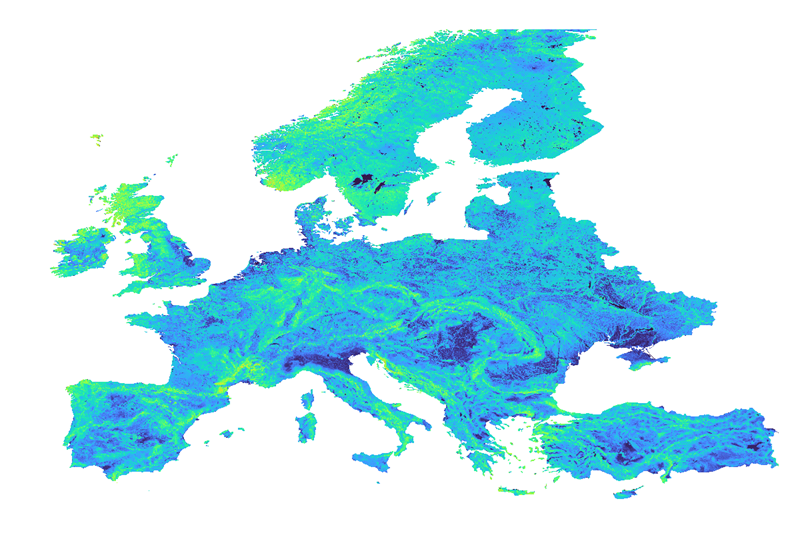
Introducing the Uncertainty Map for the New European Wind Atlas
Following the successful launch of the New Europe Wind Map in 2025, UL Solutions is pleased to announce the release of the Uncertainty Map for Europe, now available within the UL Solutions' ULTRUSTM Windnavigator platform.
As wind projects continue to expand across increasingly diverse and complex terrains, understanding where and why uncertainty arises in wind resource assessments is critical. The European Uncertainty Map represents a key step forward in enabling developers, investors, and technical teams to make better informed, risk-aware decisions throughout the project lifecycle.
A transparent view of uncertainty across Europe
The European Uncertainty Map provides a spatial representation of wind atlas uncertainty at 200 meter resolution across the continent. It translates complex model behavior and validation results into an intuitive layer that helps users quickly identify areas of higher and lower confidence in wind resource estimates.
This map is designed to complement the wind speed, offering additional context for feasibility studies, site screening, and early-stage financial assessments.
How the uncertainty is derived
The European Uncertainty Map is built on a robust, two-step methodology:
• Model-related uncertainty, capturing the sensitivity of wind modeling to key stress factors such as terrain complexity, slopes, land cover, surface roughness, and forestry.
• Empirical validation, based on cross-validation against a large dataset of meteorological masts.
• Empirical validation, based on cross-validation against a large dataset of meteorological masts.
An empirical uncertainty model was developed by analyzing how uncertainty metrics (such as standard deviation or RMSE) vary with commonly used modeling stress indicators. These relationships are used to calculate a background uncertainty value for each grid point in the wind atlas.
Known modeling errors observed at measurement locations are then incorporated through a distance-weighted correction, ensuring that the wind atlas performance is accurately reflected in the final uncertainty layer.
Designed to support confident decision-making
By making uncertainty explicit and spatially consistent, the European Uncertainty Map enables users to:
• Compare sites not only on wind potential, but also on confidence level
• Strengthen due diligence and technical risk assessments
• Improve the robustness of energy yield and financial modeling
• Communicate uncertainty more clearly to stakeholders and lenders
• Strengthen due diligence and technical risk assessments
• Improve the robustness of energy yield and financial modeling
• Communicate uncertainty more clearly to stakeholders and lenders
Whether used during early prospecting or as part of more advanced project analysis, the map helps teams move beyond single-value estimates toward a more realistic understanding of wind resource risk.
Available now in Windnavigator
The European Uncertainty Map is fully integrated into Windnavigator, alongside wind atlas layers, micrositing tools, and project workflows. Users can visualize uncertainty directly within their areas of interest and factor it into their development strategies with minimal additional effort.
With this release, UL Solutions continues its commitment to advancing transparency, rigor, and confidence in wind resource assessment—supporting more resilient and bankable wind projects across Europe.
Should you have any inquiries, proposals, or simply an interest in exploring our digital solutions, we warmly invite you to reach out to us.